
Sitting amongst dramatic cliffs that tower over the roughly 40 kilometres of coastline on Yorke Peninsula’s southern tip, the pristine beaches of Dhilba Guuranda-Innes National Park are full of surprises. Each with a unique feel, the beaches are home to shipwrecks, rock pools and dolphins.
There are at least 12 accessible beaches in the park (formerly known as Innes National Park), which are all touched by the clear blue waters of the Spencer Gulf. The beaches vary in size from a couple of metres to a couple of kilometres and some are popular surf destinations.
The park’s rugged coastline and extensive coastal dune system means that some of the beaches are easier to access than others. Access to the beaches often requires walking on a path cut in the sand dune’s vegetation or down flights of stairs built along a cliff face.
Beach access also requires paying the park entry fee and making the 300km drive from Adelaide. With stunning views and long stretches of quiet beach, even on a busy long weekend, it is worth the trip.
Pondalowie Bay
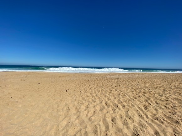
Pondalowie Bay is a quiet and slightly sheltered beach, thanks to its curved shape and a couple of offshore islands that protect it from Spencer Gulf. Located in the west of the park, it a nearly 5 kilometres long stretch of white sand bordered by high, vegetated sand dunes on one side and clear, turquoise waters on the other.
It is a beautiful place to go for a morning walk and lucky walkers might spot dolphins swimming a few metres away. Anyone who walks between the Casuarina Campground access and the boat ramp at the southern end will see a small shipwreck beached halfway between the dunes and the tideline. The exposed and graffitied hull of the O U Dog is a colourful contrast to the rusted deck and wheelhouse, which are partially filled with white sand.
The southern end of the beach is best for launching and mooring boats, rather than swimming or surfing. There are a few fishing shacks built near the boat ramp and several boat trailers are parked on the beach. The sand at the southern end is soft and a strong tide churns up the sand, hiding skates swimming in the shallow water. However, when the sun sets behind the dunes, South Island and boats moored in the bay, the view is reminiscent of an exotic beach holiday overseas.
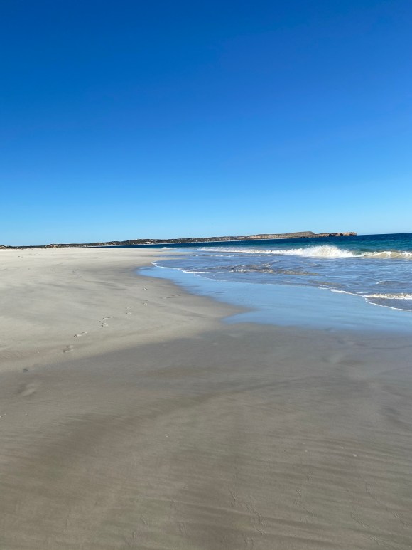
The area in front of the Casuarina Campground access is the best spot on the beach for swimming. The sand north of the Casuarina access is firm and good for walking and dolphin spotting. The northern part of the beach is also known for its surfing, with the waves becoming bigger heading north from the Pondalowie Boardwalk.
Feature: small shipwreck and dolphin spotting
Length: 4 – 5 kilometres
Access: Day parking lot by the Pondalowie Campground or nearby boat ramp on the southern end. Foot access via the Casuarina Campground, about a 10-minute walk through the dunes. Foot access via the Pondalowie Boardwalk from the Surf Break car park.
Dolphin Beach
With soft white sand, few waves and clear blue water, Dolphin Beach is a good place to go for a swim on a hot day. It is located in the north of the park and is easily accessible from the car park. There is a short 50 metre walk from the dedicated car park and wooden stairs down to the beach.
The beach is about 800 metres long, but only the half closest to the stairs is good for swimming. Walking away from the stairs on the beach, the sand gives way to a smooth granite rock shelf underfoot. There are large granite rocks to stand on at the far west end of the beach, and the waves crashing into the cliff on the far east is impressive to watch. The beach is bordered by a slightly vegetated, steep sand dune.
True to the beach’s name, visitors can spot dolphins while at the beach and they may come close to swimmers. During our visit, a pair of dolphins was swimming only a metre from two teens standing waist deep in the water.
Feature: dolphin spotting and good for swimming
Length: 800 metres
Access: Easy access from the Dolphin Beach car park. The road is unsealed past the Pondalowie Surf Break Car Park.
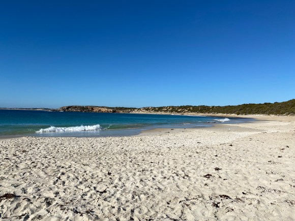
Shell Beach
Shell Beach is a popular spot for a swim and is known for its hidden rock pool at the eastern end. It is a short, 250-metre-long beach of light brown sand with clear, calm water. Visitors’ first views of the beach are from a series of short boardwalk steps down from the sand dune path at the western end of the beach. As walkers pass the sand dune’s ridge, views are of the beach sweeping out to the right in a dramatic curve. There is a large rock formation jutting up from the sand and shallow water at the eastern end. Just left of the stairs, the beach ends in a rock outcropping extending into the ocean which provides some cover from the sun.
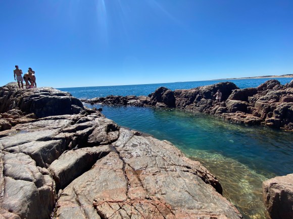
The sand is gets softer further to the east, then disappears into the rock outcropping that runs from the ocean floor to the sand dune. Walkers can navigate over the outcropping, but not shoes with sturdy soles are recommended. Those willing to clamber over the rocks and off to the left are rewarded with a chance to dip in a beautiful rock pool. The pool of water is sheltered from the waves and completely calm. It is deep enough to jump off the surrounding rocks, clear enough to see the bottom, and there is even a convenient smooth rock ledge to easily get back out of the pool.
For anyone who doesn’t want to wander out over the rocks to reach the pool, there are several smaller shallow spots of calm protected water to wade in near the start of the rock outcropping. The clear waters make it easy to see fish and sea stars in the water.
Feature: Rock pool at the far end of the beach
Length: 250 metres
Access: The beach is easily accessible from a dedicated car park via a 140-metre-long path through the dune that borders the beach, and down a few sets of wooden stairs.
Ethel Beach
Ethel Beach is named for the shipwreck buried in its sands, a strong indication that this is not a beach for swimming. The 450-metre beach of soft golden sand is wedged between the high cliffs of the park’s western edge.
The lookout sits at the top of the cliffs and the view makes the beach seem smaller than it is. Looking down on the beach it appears small and far away with a few rusted pieces sticking out of the sand. However, venture down the zig-zagging staircase along the cliff face and the scale of the beach seems completely different. The ship’s carcass juts out of the sand 6 feet high, like the rib cage of a whale, and the waves crashing on the beach are huge. From time to time, its remains are more exposed when heavy weather strips the sand away.
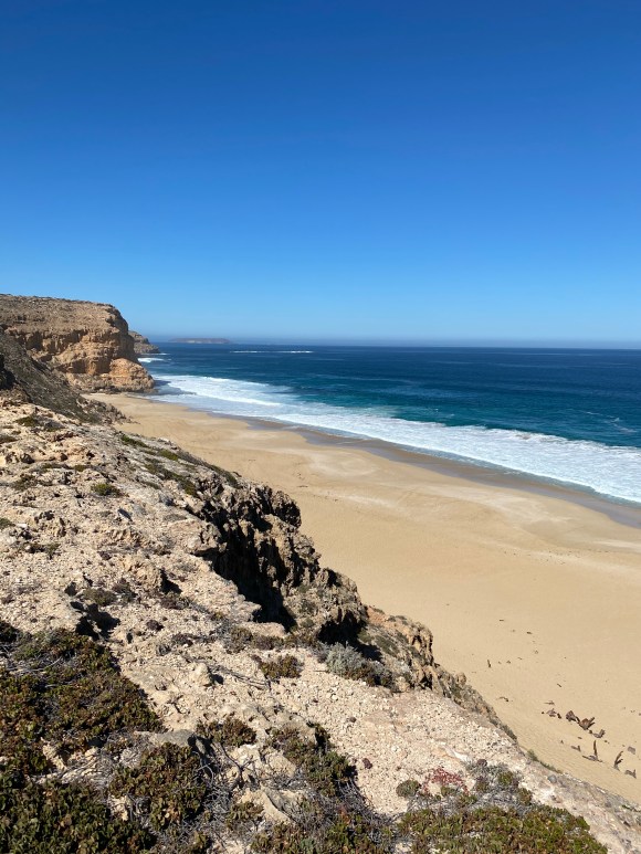
At the lookout, there is an information sign describing the fate of the Ethel, which ran aground in 1904 and eventually broke apart. The beach is also the final resting place for a smaller ship, which unsuccessfully tried to salvage the Ethel and made it away but ironically crashed many years later in the same spot.
Feature: shipwreck and towering cliffs
Length: 450 metres
Access: The car park is right in front of the lookout and entrance to the stairs. The stairs are the only way down to the beach.
Other posts in the Innes National Park Series:


The Essentials
Getting There
Innes is located on the south-western tip – or toe – of Yorke Peninsula. It is about 300km, or a three-hour drive, from the City of Adelaide.
By Car
Driving is really the only way to get to Innes.
From Adelaide, head north towards Port Wakefield via the Northern Connector (M2) and the Port Wakefield Highway (A1). Keep left past Port Wakefield to take the Copper Coast Highway (B85) for a few kilometres before turning left at the roundabout onto the Yorke Highway (B86).
Continue to follow the Yorke Highway as it heads inland after James Well. Pass through Minlaton and Warooka, following the signs to Marion Bay.
Alternatively, follow the east coast of the peninsula for a bit longer, staying left after James Well to take the St Vincent Highway (B88). After Stansbury, follow the signs to Yorketown then head towards Warooka and Marion Bay.
After Marion Bay, the Yorke Highway heads straight into the national park.
Rest Stops
There are plenty of excellent small towns on the Yorke Peninsula. However, even if you plan to head straight to Innes, with a three-hour drive you are probably still going to need to stop for fuel, food or the bathroom.
- Port Wakefield: A popular spot to stop, it gets very busy on a long weekend as it is the jumping off point for several destinations. Port Wakefield has several petrol stations and a few bakeries. Follow the long lines for the good ones.
- Ardrossan: Has a good bakery and a Foodland.
- Minlaton: Home to Watsacowie Brewing Company
- Port Vincent: Has a good fish and chips shop on the coast and a small IGA for essentials.
- Marion Bay: The last fuel stop before the park. There is also a pub.
Opening Hours and Fees
The park is open daily, except on Catastrophic Fire Danger days. It may be closed on days of Extreme Fire Danger.
The Visitor Information Centre is open daily from 10:00 am to 3:00 pm.
Entry Fees
Vehicle entry fees apply per day.
Regular: $11 per vehicle
Concession: $9 per vehicle
Campers only need to pay the entry fee once for the duration of their stay.
Food & Beverage
There are picnic areas and BBQ facilities available. However, as a national park, visitors to Innes should leave no trace. There is no water or food available to purchase in the park, and there are no bins – visitors are expected to take their rubbish with them.
Technology
Innes is quite remote. Mobile phone coverage gets spotty in areas.
